Applying Experimental Mathematical Models to Monitor Soil Erosion and Degradation in Al-Jabal Alkhdar, Libya
DOI:
https://doi.org/10.63318/waujpasv4i2_65Keywords:
Water erosion, Soil degradation, Experimental modelsAbstract
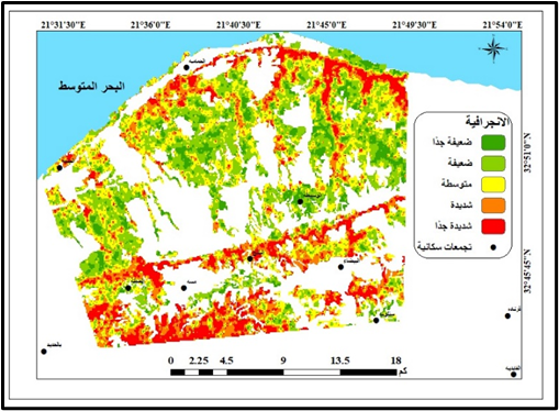
Soil erosion by rainwater and surface runoff is a major cause of the degradation of slope lands in Al_Jabal Alkhdar, Libya. The current study tested, compared and evaluated some empirical mathematical formulas for estimating water erosion that are easy to apply and usable in data-limited areas. The study used the equation (RUSLE) and the Morgan-Fenny equation (MMF) in measurements and calculations to estimate annual soil erosion by rainfall. Erosion risk maps were also prepared using climate, soil, topography, and vegetation cover data. To assess the validity of the empirical formulas, statistical comparisons were made against the field estimation of erosion, measured under natural rainfall conditions and rainfall simulation experiments. The results for both equations showed that Typical Mediterranean Red soils (TR) were the least susceptible to erosion and the most resistant to water erosion, while Shallow Mediterranean Red soils (LR) were the most susceptible to erosion. Empirical models have agreed that slight to moderate slopes are best suited for agricultural investment without causing increased soil degradation when the main crops are fodder and grain crops, especially barley, even in the presence of fruit trees. The empirical models under comparison did not agree on the estimated annual loss amounts, as the RUSLE model ranged between moderate to severe, while losses ranged from slight to moderate according to the MMF model. Comparing the results of the empirical equations with the results of the field measurements confirmed that the MMF model was the closest to the actual conditions, recording annual losses not exceeding 5 tons per hectare, and achieving good statistical correlation with the field measurements, reaching R=0.69. While the RUSLE model showed an overestimation, recording annual losses of up to 30 tons per hectare on slight to moderate slopes, and achieving a lower degree of correlation with field measurements of R=0.52. The current study encourages the use of highly efficient and low-cost quantitative experimental measurement tools that may contribute to a realistic assessment of the phenomenon of water erosion on the slopes of Al-Jabal Alkhdar. These tools can also contribute to expanding, developing and monitoring the natural resources database, which may contribute in the future to the optimal application of recommendations and requirements for integrated and sustainable management on arid and semi-arid lands in Libya, and reduce the risks of erosion and flooding from deteriorating slopes.
Downloads
Downloads
Published
Issue
Section
License
Copyright (c) 2026 Authors

This work is licensed under a Creative Commons Attribution-NonCommercial 4.0 International License.
This journal uses Creative Commons Attribution-Noncommerical 4.0 International License (CC BY-NC 4.0), which permits use, sharing, adaptation, distribution and reproduction in any medium or format, as long as you give appropriate credit to the original author(s) and the source, provide a link to the Creative Commons license, and indicate if changes were made. To view a copy of this license, visit https://creativecommons.org/licenses/by-nc/4.0/.
Copyright of articles
Authors retain copyright of their articles published in this journal.