The Role of Spatial Technologies in Modeling Changes in Green Spaces in the City of Tobruk: A Study in Applied Geography
DOI:
https://doi.org/10.63318/waujpasv4i2_34Keywords:
Remote Sensing, Green Spaces, GIS, Index NDVI, Improved Change Detection ToolAbstract
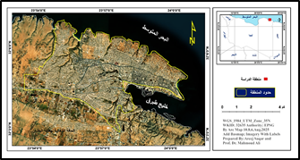
This study aims to highlight the role of remote sensing technologies. The study utilized RS and Geographic Information Systems (GIS) to understand the current state of green spaces in Tobruk, reveal changes in these spaces between 2013 and 2025, and assess the effectiveness of these modern technologies in analyzing and monitoring green spaces using the NDVI spectral index. It also aimed to produce spatial and temporal maps and model them cartographically by comparing different classifications using the Change Detection tool. The results showed that the NDVI reached its highest value in 2013 at 3.37%, and in 2025 it reached 3.93%. This indicates that vegetation cover is unstable, due to the nature of the climate, particularly fluctuating rainfall rates, and the continuous urban expansion driven by population growth. the study concluded that green spaces appear in some locations, particularly in the valley corridors extending from east to west in the northern part overlooking the Mediterranean Sea, and some of them are distributed in the south eastern part. Through the use of the developed tool and the values obtained from the NDVI spectral index, it was shown, according to the description of the change, that there is a severe decrease between 2013-2025 AD by an area of 0.37 km² of the total area of the city, while there is a severe increase in the density of vegetation cover by an area of 0.49 km². The study recommended the need to pay attention to remote sensing and geographic information systems technologies, and employ them in affiliated institutions in the field of environmental monitoring, due to their efficiency in monitoring the environment, their speed in implementation, and their high accuracy in giving results, according to the desired goal.
Downloads
Downloads
Published
Issue
Section
License
Copyright (c) 2026 The authors

This work is licensed under a Creative Commons Attribution-NonCommercial 4.0 International License.
This journal uses Creative Commons Attribution-Noncommerical 4.0 International License (CC BY-NC 4.0), which permits use, sharing, adaptation, distribution and reproduction in any medium or format, as long as you give appropriate credit to the original author(s) and the source, provide a link to the Creative Commons license, and indicate if changes were made. To view a copy of this license, visit https://creativecommons.org/licenses/by-nc/4.0/.
Copyright of articles
Authors retain copyright of their articles published in this journal.